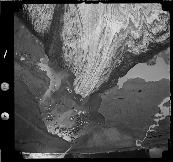
In the span of a single human lifetime, large swaths of Icelandic glaciers have melted away.
Now scientists have documented the sheer magnitude of the change by using composite images taken of Icelandic glaciers in the 1980s and comparing them with modern-day drone images.
The images, from Kieran Baxter of the University of Dundee, Scotland, show a group of Icelandic outlet glaciers on the south side of one of Europe’s largest ice caps, Vatnajökull. The images are side-by-side comparisons of the same scenery, taken just decades apart. In recent years, Iceland’s glaciers have lost about 40 square kilometers annually, according to the Icelandic Meteorological Office.
“The glaciers in Iceland, and around the world, are down-wasting at an alarming rate as a result of the climate crisis,” Baxter said. “We have a limited opportunity to document these rapidly changing landscapes before they are gone.”

The National Land Survey of Iceland took aerial mapping photographs in the 1980s by plane, capturing thousands of black-and-white shots of the landscape. Baxter and his team took the mapping photographs and put them through a 3-D photogrammetry software program to recreate a three-dimensional model of the landscape. The end product—composite images made from multiple photographs—shows an oblique view of the landscape.

Baxter then went one step further: He traveled to the Vatnajökull ice cap to photograph its glaciers using drones. He partnered with the University of Iceland and Icelandic Meteorological Office for the project.
Noticeable changes jump out from each photographic comparison. Glaciers are receding, like the end of Skálafellsjökull glacier.

But the massive rivers of ice are also shrinking in height, like Hoffellsjökull glacier.

The outlet glaciers pictured here are suffering some of the greatest losses on the ice cap. On average, the height of the ice for the Vatnajökull ice cap has decreased by about the height of an average 5-story building in the past 30 years. But for the pictured glaciers? Their ice levels have dropped the length of a 20- to 30-story building during the same period.

Baxter previously documented ice melt on the Alps’ highest peak, Mont Blanc, using photographs taken by a Swiss photographer a century ago.
A group of scientists convened by the United Nations released a report on the health of the world’s cryosphere and oceans earlier this year, and the report predicted that 80% of the total ice mass held in smaller glaciers will be lost by 2100 if action is not taken to curb emissions.
Baxter said that the researchers are about 2 years into their project and plan to experiment with making videos of ice loss in the future. They could also go back even further into the troves of available historical images. “The archives are huge, and we have barely scratched the surface.”
—Jenessa Duncombe (@jrdscience), News Writing and Production Fellow
