
The interior of Greenland’s ice sheet doesn’t usually make headlines: It’s a layer of compact snow and glacial ice at high elevations that typically doesn’t contribute to runoff that drives sea level rise.
But a new study suggests that this may change: More runoff may come from Greenland’s interior because of a newly discovered phenomenon called ice slabs. The slabs are layers of ice that exist just below the snow’s surface, where porous snow usually sits. Ice slabs can extend for tens of kilometers and grow to over 16 meters thick.
The latest results reveal that 5% of Greenland’s ice sheet has ice slabs under the surface, and using modeling data, scientists project that ice slabs will double in area by midcentury. The news could mean that Greenland will contribute more to sea level rise because the majority of mass loss from the ice sheet comes from meltwater runoff.
“Core After Core of Solid Ice”
Scientists discovered ice slabs only in the past decade. Michael MacFerrin, a lecturer at the University of Colorado Boulder, first encountered ice slabs while drilling ice cores in southwestern Greenland in 2012. He noticed something unusual about the ice cores: Instead of finding cores made of snow, MacFerrin found “core after core after core of solid ice.” It seemed that higher temperatures from climate change were melting and refreezing the snow into solid ice.
MacFerrin knew this could spell trouble for the ice sheet. At midelevations where the researchers were drilling, the snow beneath their feet should have been a granular type of snow called firn. Firn is so porous that it allows meltwater at the top of the ice sheet to percolate downward, helping compact the snow into glacial ice over time.
But ice slabs would throw a wrench into this process. Meltwater wouldn’t be able to infiltrate the ice sheet, leaving it no choice but to flow downhill toward the ocean. Later that year, Greenland saw one of the largest melt years on record, and MacFerrin saw satellite images of meltwater streaming down the same region he’d pulled his cores from.
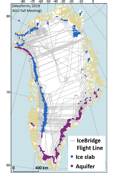
“The Size of West Virginia”
In the years following, MacFerrin and his colleagues mapped the extent of ice slabs in Greenland using ice cores and radar. Their map is the first to show the extent of ice slabs across Greenland.
The team used two types of radar data: one from ground-penetrating radar from an antenna towed behind a snowmobile along a 45-kilometer transect and the other from freely available accumulation radar data from a NASA IceBridge mission that measured the near-surface ice over much of Greenland. The radar data revealed ice slabs beneath the surface of the ice, and the team members checked their results against 17 ice cores drilled in southwestern Greenland.
The results showed that southwestern Greenland is ground zero for ice slabs, along with a big swath in northeastern Greenland. The slabs covered an area roughly the “size of West Virginia,” said MacFerrin.
From Ice to Sea
MacFerrin worries that the icy layers could have consequences for global sea level rise.
The team used three regional climate models forced by two greenhouse gas emission scenarios: one with moderate warming and the other with little action taken to curtail emissions. Trends in Greenland’s melting have been following the highest greenhouse gas emission scenario so far.
According to model projections, the ice slabs could double the amount of sea level rise from Greenland’s interior in the coming century.
Adam Schneider, a postdoctoral scholar at the University of California, Irvine who was not involved in the study, called MacFerrin’s team the “foremost experts” investigating the question of future climate impacts on runoff patterns and sea level rise. Schneider plans to improve his ice sheet model using insights from MacFerrin’s work.
MacFerrin said that future monitoring is necessary to track the extension of ice slabs throughout Greenland and pointed to microwave data from satellites as the best way to keep a keen eye. In terms of what more runoff streaming off Greenland’s middle- to high-elevation regions could mean for the ice sheet, “we don’t yet know what all the impacts on ice dynamics are going to be,” MacFerrin said. “That’s a big question.”
MacFerrin presented the research at AGU’s Fall Meeting 2019 in San Francisco, Calif.
—Jenessa Duncombe (@jrdscience), News Writing and Production Fellow