
A vanished airliner rather than scientific curiosity prompted a recent extensive campaign to map a large swath of the seafloor, one of the last unexplored frontiers of our planet. Now these data have been publicly released for the first time and may offer a lasting boon to science.
On 8 March 2014, Malaysia Airlines flight MH370 took off from Kuala Lumpur en route to Beijing, lost contact with air traffic control, and disappeared. The Boeing 777, with 239 people on board, is presumed to have veered wildly off course, eventually crashing into a remote part of the southern Indian Ocean.
Searching for Debris
In the days and weeks following the disappearance of MH370, boats and aircraft scoured the area in search of debris. Wreckage found in the western Indian Ocean allowed researchers to estimate where the aircraft might have entered the water.
Between June 2014 and June 2016, scientists used ship-mounted sonar technology to map the topography of the seafloor in the MH370 search area roughly 2000 kilometers off the western coast of Perth, Australia. Despite having to penetrate more than 6000 meters of water in some places, these new observations yielded maps with at least 15 times the resolution of older maps. That substantial increase in resolution allowed researchers to record details of seafloor features such as canyons and landslides. These data can further our understanding of the deep-ocean floor and forces, like earthquakes, that shape it, researchers suggest.
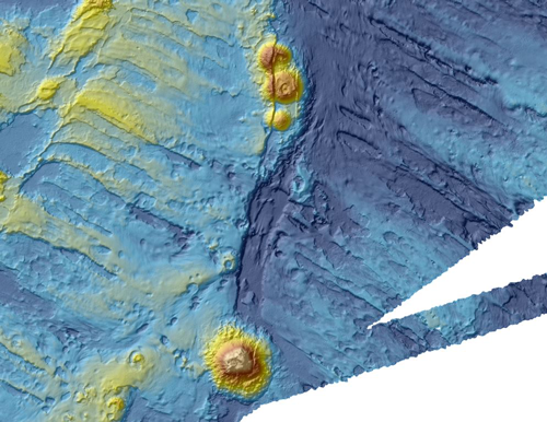
The data release included videos that give viewers three-dimensional tours through some of the seafloor regions mapped by the search.
Fly-through of Broken Ridge and Diamantina Trench from © Commonwealth of Australia (Geoscience Australia) 2017 on YouTube.
A Thoroughly Mapped Region
“It is estimated that only 10 to 15 per cent of the world’s oceans have been surveyed with the kind of technology used in the search for MH370, making this remote part of the Indian Ocean among the most thoroughly-mapped regions of the deep ocean on the planet,” according to aquatic and environmental chemist Stuart Minchin. He’s chief of the Environmental Geoscience Division of Geoscience Australia, the main Earth science agency of the Australian government. The agency, which served as an adviser for the seafloor mapping, publicly released these detailed maps of the Indian Ocean seafloor earlier this month. Geoscience Australia also incorporated the data in an interactive story map on its website.
The extensive search of the seafloor spanned more than 275,000 square kilometers, but no additional wreckage from MH370 was found. The presumed crash remains one of the greatest mysteries in aviation history. In January 2017, the governments of Malaysia, China, and Australia jointly announced that the search for MH370 would be suspended until “credible evidence is available that identifies the specific location of the aircraft.”
However, scientists are looking forward to analyzing the trove of seafloor data that was collected. “The reason we mapped this area was of course to find the aircraft and bring closure to the families, but it is a unique data set that would never have been collected without the search,” says Minchin.
—Katherine Kornei (email: [email protected]; @katherinekornei), Freelance Science Journalist