A team of 18 researchers has now mapped more than 61,000 structures in the Maya lowlands. How? Two words: airborne lidar.
The scientists conducted aerial surveys of northern Guatemala, repeatedly flying over long–abandoned sites of the ancient Maya civilization that once thrived between 1000 BCE and 1500 CE. The lidar data collected from these surveys map in fine detail the 3-D topography of the region, resolving ground features as minute as 1 meter. The researchers published their maps and their interpretations of those maps today in Science.
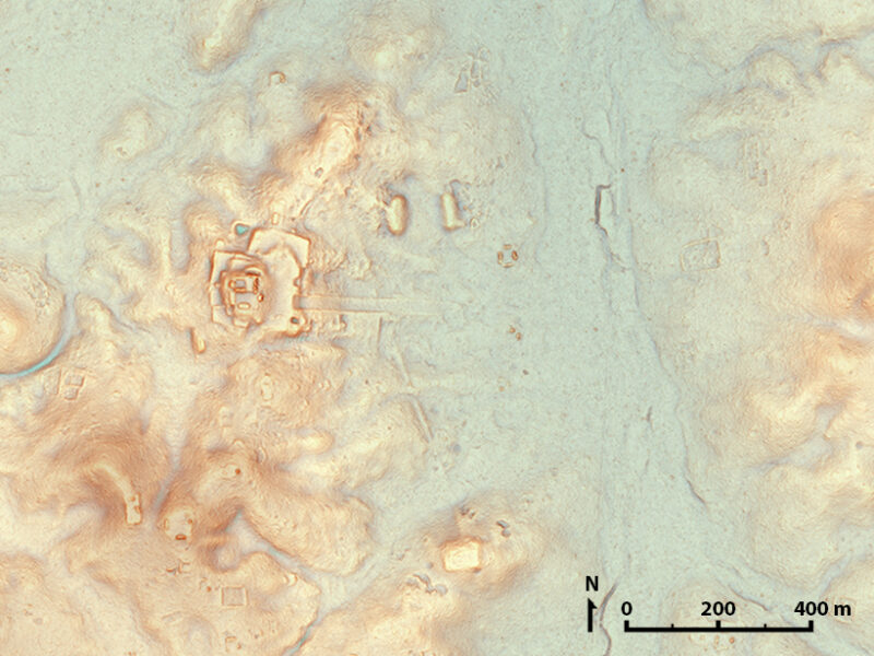
One such map is the image above. Made from the lidar measurements, the map shows topography under the jungle canopy, revealing Maya settlements now in Guatemala that stood north of the ancient city of Tikal. A smattering of buildings, both large and small, dot the hillsides, some of them newly discovered in the most recent study.
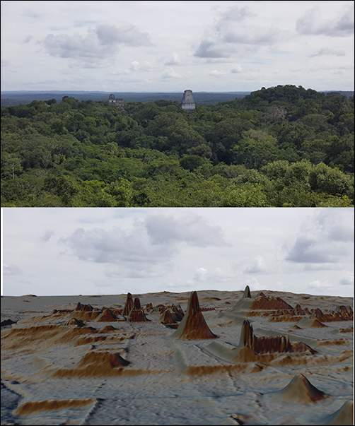
Archaeologists can toil for years mapping one ancient Maya site by foot, wading through the dense tangle of jungle that blankets the region. But with lidar instruments, scientists can map in fine detail buildings that lurk beneath the undergrowth from above.
The trick to peeling back dense vegetation involves lidar’s lasers, which rapidly pulse from low-flying planes. These pinpoints of light penetrate through tiny gaps between leaves to get to whatever may lie below, before reflecting back to the aircraft above. With a little processing, scientists can use the time it takes for light to travel and reflect back to reveal precise information about the elevations of the ground and structures upon which the jungle grows.
The team scanned more than 2,100 square kilometers of terrain in what they say is “the largest single lidar survey of Mesoamerican archaeology.” The results call into question many of the accepted theories of Maya life, the authors explain.
For example, evidence of extensive agricultural practices, from terraces to modified terrain, hints at a civilization intimately linked with agriculture, a fact not well understood before the study. The team also found evidence of elevated roads linking many of the urban centers, suggesting a closer connection between cities than earlier thought.
“Seen as a whole, terraces and irrigation channels, reservoirs, fortifications and causeways reveal an astonishing amount of land modification done by the Maya over their entire landscape on a scale previously unimaginable,” first author Marcello Canuto said in a press release about the project.
These findings may revise what scholars believe about Maya economics, population, and agriculture, the authors speculate, and the data in hand could fuel more discoveries yet to come.
Lidar is “revolutionizing archaeology the way the Hubble Space Telescope revolutionized astronomy,” coauthor Francisco Estrada-Belli told National Geographic earlier this year. “We’ll need 100 years to go through all [the data] and really understand what we’re seeing.”
Watch a video of lidar images created by the study that shows the towering temples of the ancient city of Tikal in Guatemala. The video was created by Luke Auld-Thomas and Francisco Estrada-Belli/Foundation for Maya Cultural and Natural Heritage (PACUNAM).
—Jenessa Duncombe (@jenessaduncombe), News Writing and Production Intern